The Christchurch City Council, Waimakariri District Council, Selwyn District Council and Environment Canterbury also endorsed the Indicative Business Case at their meetings on 16 & 17 May. The next step is for the Waka Kotahi Board to consider the Indicative Business Case in July.
You can find out more information about the next steps for the Mass Rapid Transit work below.
Mass Rapid Transit (MRT), where we move people more quickly and reliably on transport systems, is a project that could help to meet our communities’ aspirations for a well-functioning and sustainable city that is easy, safe, resilient, healthy, and enjoyable to live in and move around in the future.
The Mass Rapid Transit Indicative Business Case / turn up and go investigation will identify whether a future investment in Mass Rapid Transit in Greater Christchurch is justified, and its most suitable route into the city.
We want turn up and go/MRT to support and encourage the urban form changes our communities have asked for - more housing, jobs and activities that can be accessed easily in central and suburban centres.
Previous work on turn up and go/MRT has found that its viability is very dependent on intensification occurring along the corridors/around the stations.
Turn up and go/MRT is just one possible part of a wider integrated and effective public transport improvements plan for Greater Christchurch. If we decide to progress turn up and go/MRT, it will not get underway immediately. We need to start planning now so we will be ready when we need it in the future.
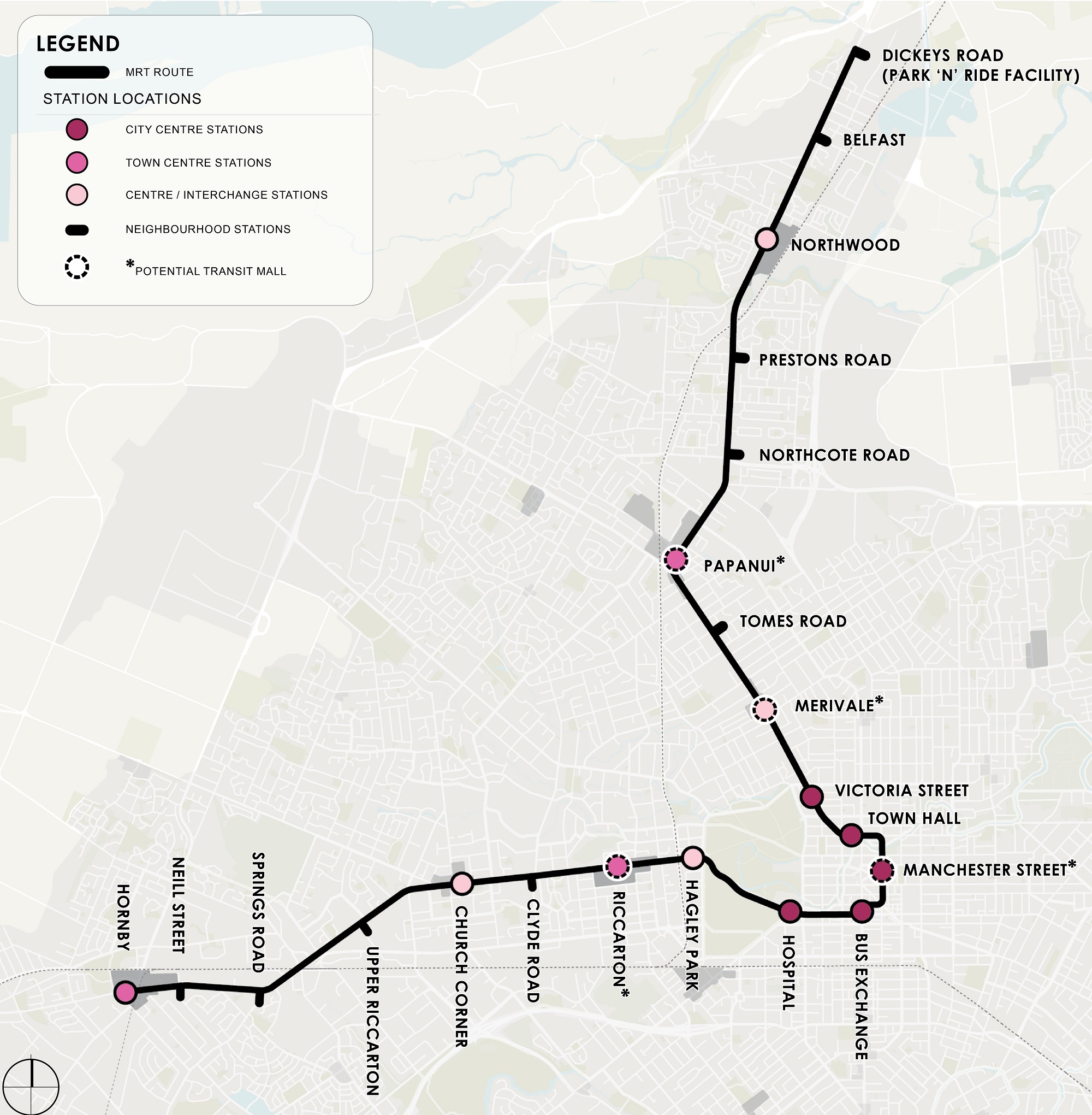
We investigated several routes for a new public transport service, and we evaluated each. After a lot of analysis, we have developed a preferred route connecting the central city to Belfast in the north and Hornby in the southwest which we are calling the ‘turn up and go’ public transport service.
Why there?
Because that's where people and businesses are already concentrating and this growth is forecast to continue, so it will enable more of us to connect easily and sustainably.
We’re still exploring what type of vehicle will best suit this new service; both vehicles that run on rails or tyres are being considered. We're also looking at how we fit this service within our existing road corridors and how we could build and stage it.
Mass rapid transit
The turn-up-and-go public transport service we are suggesting is a type of mass rapid transit (MRT).
Mass rapid transit is a step up from conventional public transport. As the name suggests, it is about moving more people quickly and reliably to where they want to be.
Mass rapid transit systems can take different forms, but in general, they operate on a permanent route (road or rail) that is separated from other traffic. Mass rapid transit systems typically have:
Priority and dedicated right of way: enabling reliable travel by avoiding conflicts with other vehicles.
Speed: travel times that are faster than other options - ideally travel to and from the CBD at least as fast as the private car.
Frequency: enable users to 'turn up and go' at most times of the day.
Reliability: consistently on-time.
Capacity: allows the movement of large numbers of people in a short amount of time.
Developing the business case
In June 2021, the Greater Christchurch Partnership released an Interim Report(external link) which illustrated the importance of integrating land-use and mass rapid transit decisions, with its use highly dependent on the land use it services.
One scenario we explored had the largest catchment of people living within walking distance and would help to link these people to the places they work, shop, relax, and live - this is the suggested ‘turn up and go’ route (see map at bottom of this section).
This service would travel along Papanui and Main North Roads to the north as well as Riccarton and Main South Roads to the south-west. The route would use Tuam, Manchester and Victoria Streets in the city centre.
Why are we suggesting this route?
About a third of the Greater Christchurch population could live within these corridors in the future.
It will help development happen in the right places, with growth focused around existing centres and key destinations.
It will encourage investment in higher-density housing and mixed-use neighbourhoods.
It will improve access to key employment hubs including in the central city.
To ensure the districts are well connected to Christchurch City we are proposing improved park ‘n’ ride facilities in key townships and increased frequency of direct bus services that connect to the central city using the motorway corridors. We also propose connecting the districts to the new turn up and go service with park ‘n’ ride facilities at Hornby and Belfast, and providing better connections within the districts themselves.
Suggested Turn Up and Go route from Hornby to Belfast
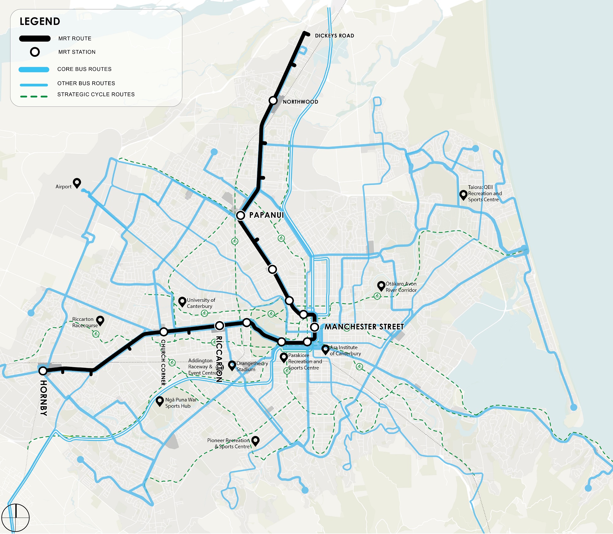
Integration with the existing transport network
Suitable vehicles
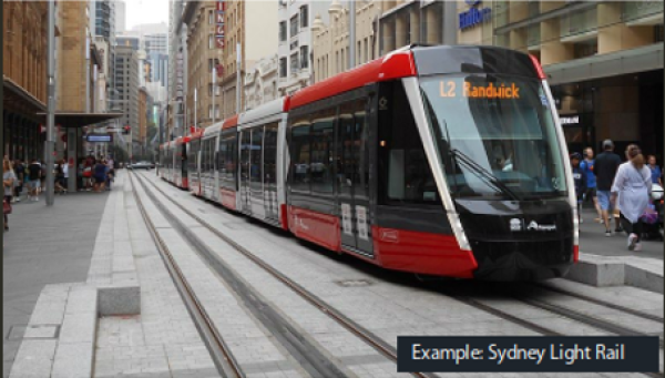
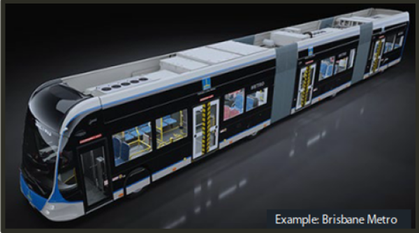
Two kinds of vehicle would be suitable for this service. Either a light rail or bus (metro).
Light rail
Pros:
Rails in the ground give people the perception of permanence and reliability.
Light rail can carry more people and more carriages can be added easily. Light rail trains/trams can carry up to around 300 people.
Cons:
Light rail tracks can’t travel over heavy rail tracks so one service would need to go over or under the other where they cross - bridges or underpasses would be needed.
More infrastructure (rails, bridges) means a higher cost to build.
Light rail can be noisier than tyred vehicles.
Bus (Metro)
Pros:
Less infrastructure means a lower cost to build and easier rollout.
A wheeled vehicle means:
Flexibility to avoid traffic disruption.
More ability to stage the rollout.
More resilient to natural disasters.
Tyred electric vehicles are often the quietest option.
Cons:
Metro-style buses can carry a maximum of around 150 people and vehicles cannot be joined together to add additional seats.
Possible roll-out
There is a long way to go before we start building anything.
If it’s decided this project is a great idea and we get funding, we will first, work through a concept design and then more detailed designs. We will also need to buy some property and get consents.
There will be more chances to give feedback along the way. This said we think we would build this service in two phases.
Phase one is likely to be from the central city to around Papanui in the north and Church Corner in the southwest.
Phase two would extend it out to stations in Belfast and Hornby.
Other options investigated
Why not use our existing rail tracks or the motorways?
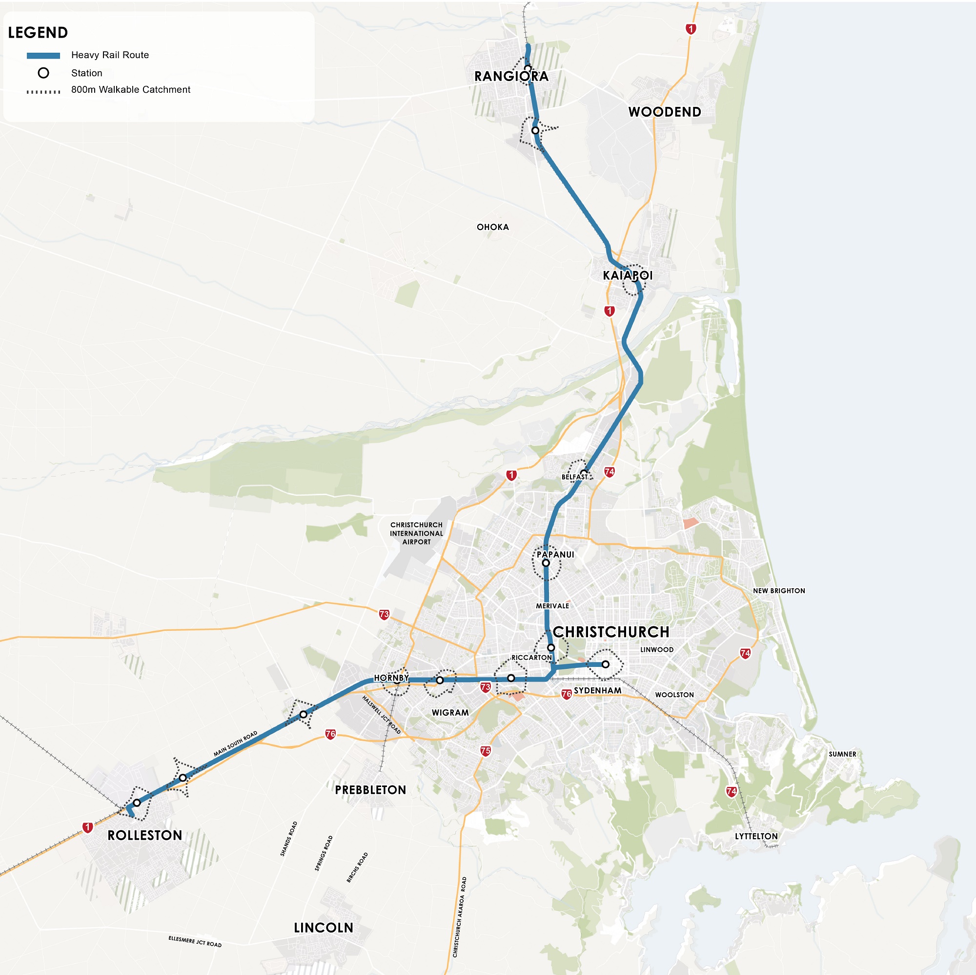
Using the existing railway line is one of the options we have considered along with using the motorway corridors.
These options didn’t stack up against the street running route we have landed on, mainly because they weren’t able to collect enough passengers along the route and didn’t take them where they wanted to go.
There is a map at bottom of this section that shows the potential route for ‘start-up’ passenger rail service and indicative station locations.
Why using our existing heavy rail wasn’t the best option for a turn-up-and-go service?
The existing railway line doesn't go through the central city.
A new station/s would be needed on the existing line as close to the central city as possible (eg near Riccarton Road or Colombo Street/Moorhouse Avenue) and passengers would still need to walk or transfer to a bus to get to the central city. To reduce the need to transfer, we would have to tunnel or trench a railway line into the central city.
The current rail infrastructure limits the number of trains that can operate. Most of the railway line between Rolleston and Addington and all the line between Addington and Rangiora is a single track. This means trains can only go in one direction at a time in these sections, which limits the number of services that can be run. Other infrastructure, such as busy level crossings and the train signalling system, place further limits on the number and reliability of services that can be run.
The existing railway lines are already busy with the critical and growing task of moving freight. High freight demand between the inland port (Rolleston) and Lyttelton Port makes operating a regular and frequent passenger train impossible on the current infrastructure. Moving this freight to the road network to ‘make room’ for passenger trains would create significant congestion and increased emissions.
The existing railway lines are not where most people are now or where they will live/work/play in the future. Rail corridors are not necessarily well-suited to encouraging land uses around them that are city-shaping and improve liveability. To succeed the chosen solution needs to lead to more vibrant neighbourhoods and key centres and encourage population growth along the entire corridor.
While heavy rail is not the best option for a turn-up-and-go service of this sort, this does not mean passenger rail will not happen in Canterbury in the future. And it is worth noting that heavy rail will continue to play an important role in moving freight, a role that is important to grow in the future to support our economy and a healthy environment.
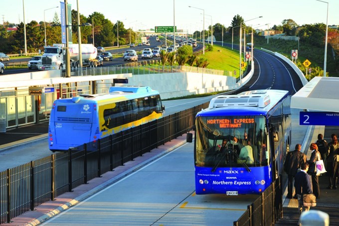
Why the motorway corridors weren’t the best option for a turn-up-and-go service?
We did consider a service that would run along the existing motorways. This would have a similar route to the direct buses offered now but would be much more frequent and look more like the Auckland Northern Busway.
See the image at bottom of this section of the Northern Busway in Auckland that runs along the eastern side of the motorway.
The service would exit the city via the motorway corridors and have longer spacing between stations than the turn up and go service we are suggesting.
This motorway running option worked better for long distance commuters as fewer stations offered a faster travel time. However, it wasn’t as good for these reasons:
There is limited opportunity for this option to stimulate growth and activity within Christchurch City.
The size of our regional centres aren't large enough yet for a light rail or a metro style bus service to be cost-effective.
There are fewer people who live within walking distance of a station. The majority of Greater Christchurch’s population is located within a 10 km radius of the city centre and this option had fewer stops/stations in this area.
It is worth noting that the direct bus services and park ‘n’ ride facilities, already running to Rangiora, Kaiapoi, Lincoln and Rolleston, provide a quicker and more direct route to central Christchurch than the turn-up-and-go service would be able to provide. Improvements to these types of services look like the best option for central city commuters from the districts.
Maps and images - click to enlarge
Existing rail link with indicative link to the Central City
Northern Busway in Auckland that runs along the motorway
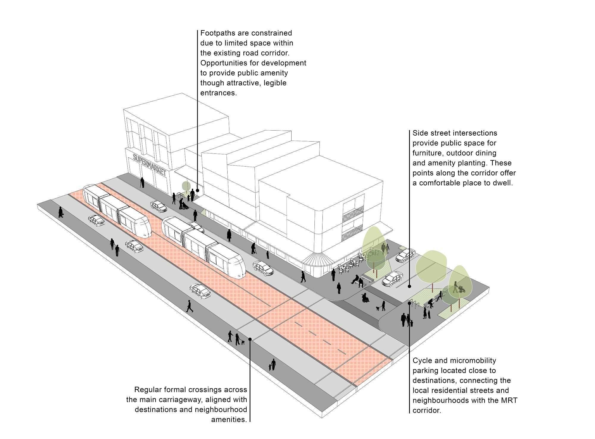
Design of the corridor and stations to support this service
In most areas, the turn-up-and-go public transport service and its stations will need a dedicated lane within the roads to run along. This means there will be less space for other types of transport and road uses.
As we want the turn-up-and-go service to be the best transport option for getting around, it will be given priority and other types of transport may need to wait, travel more slowly, have less space or go a slightly different way.
We know there are some areas along our suggested route where there is not enough space for all the types of transport and road uses we have now. Areas like Papanui, Merivale, Victoria Street and Riccarton. We don’t have solutions for these areas yet but here are some of the options we will be considering if this project moves forward:
Purchasing more land - so we can fit in more types of transport and road uses
Compromising – this could be a combination of slower narrower lanes for private cars, limited access or less/no on-street parking.
Separation – putting some types of transport over or under, such as a bridge or tunnel
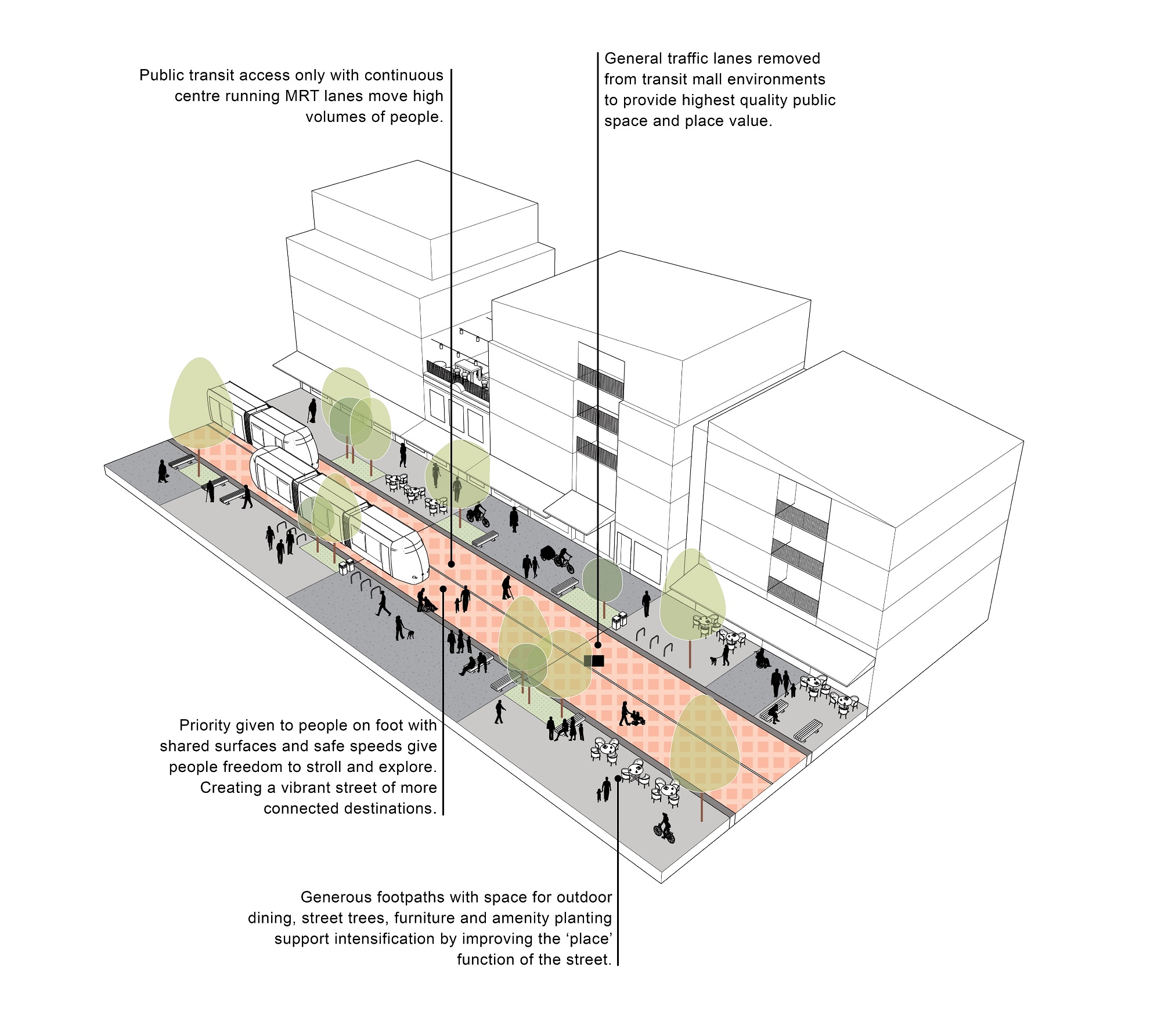
Creating a section of road dedicated to public transport, people on foot and public space at key centres – these are called transit malls
Cashel Mall and some areas of Oxford Terrace are good examples of transit malls, where private cars are restricted or highly controlled to enable those walking to have priority and safe access to public transport and public spaces.
The remaining space can then be used for walking, cycling, street furniture and more relaxed access to shops and dining.
If this project goes ahead, we will develop a range of improvements to activate the streets around stations and better connect people to where they want to go. This will help make public transport a more attractive option and encourage people to consider public and active travel options.
The city centre streets need to support the highest density of residential and commercial activities at all hours of the day and night. There will also be opportunities to improve the look and feel of these areas so they are attractive and safe.
There are also some areas along the suggested turn-up-and-go route that are quite wide already, such as Main North Road. These areas provide the opportunity for greenspaces and more generous footpaths.
Images of example layouts - click to enlarge
Example layout of a central city one-way street environment
Example of a transit mall with no motor vehicle access
Example layout of an urban connector route
What we need to do beyond a turn up and go service
We know adding a turn-up-and-go service and investing in public transport is only part of the answer to achieving our ambitions for reducing our transport emissions, improving accessibility, avoiding congestion, and making it easier for people to get around without a car as our population grows.
Not only do we need to invest more in our public transport system to improve its frequency, reliability and convenience, we also need to invest more in options for people to use active ways of getting around like cycling and walking. We need to change the way we use our road space to make way for public transport and active travel and use cycleways to connect key centres and destinations.
The creation of low-speed zones in residential areas is a key part of ensuring streets are safe for our communities, and supports people’s aspiration for streets and public spaces that are designed more for people and less for cars.
We will also work with mana whenua to improve public transport connections between Māori Reserve Land and the wider public transport system as well making walking and cycling options easier and safer.
As more of our population live and work in centres and along public transport corridors into the future, more people will find it easier to choose public transport, walking and cycling to get where they want to be.
It is also important that our future transport system protects the freight transport network that is so critical to our local economy, and to our wider region. We will support the transition of freight to more sustainable modes like rail and coastal shipping and ensure regional freight routes are protected and industrial land within Greater Christchurch is well located with freight connections.
We all have a role to play to ensure the future of transport in Greater Christchurch is effective, sustainable and safe for all.
The Whakawhanake Kāinga Committee met on 12 May 2023 and endorsed the Mass Rapid Transit Indicative Business Case(external link) [PDF, 18 MB], called ‘turn up and go investigation’ during the engagement. The Christchurch City Council, Waimakariri District Council, Selwyn District Council and Environment Canterbury also endorsed the Indicative Business Case at their meetings on 16 & 17 May. The next step is for the Waka Kotahi Board to consider the Indicative Business Case in July.
If the Indicative Business Case is approved and funding is confirmed for the next phase of the business case process, the next step will be to investigate in more detail the design of the corridor and stations along the route.
We also need to consider a range of technical issues like what consents and land acquisition will be necessary, how the transport network around stations might need to changed and what neighbourhood planning needs to happen. This stage of work is likely to take a few years.
We will continue to provide feedback on the turn up and go service together with the Greater Christchurch Spatial Plan and other transport improvement plans, as these projects all work together.